 562 628 1675
Hurricane Odile
17 Sep 2014
Hurricane Odile made landfall at Cabo San Lucas, Mexico at approximately 9:45pm on Sunday, September 14, 2014. The Category 3 hurricane had wind gusts estimated to be 127 mph at landfall. The storm caused flooding and wind damage in the region, as well as wide spread power and water outages as it moved up the north-south axis of the peninsula. Figure below is from the NOAA/NWS and shows the best track representation of the storms location and intensity at 6-hr interval over its lifetime. These best track positions and intensity (maximum 1-minute sustained surface wind speed and minimum sea-level pressure) are based on a post-storm assessment of all available data from the NOAA/NWS National Hurricane Center (NHC) storm advisories.
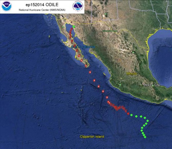
Figure 1. NOAA/NHC best track for Hurricane Odile
Figure 2 below shows the NOAA/NWS best track wind swath for the Hurricane Odile. This is created by accumulating wind radii of the best track for the storm over the course of an ongoing tropical cyclone. The swath shows areas affected by sustained winds of tropical storm force (34 Knot or 39 Miles Per Hour), 50 knot (58 Miles Per Hour) and hurricane force (64 knot or 74 Miles Per Hour) from a tropical cyclone. These data represent maximum possible extent of a given wind speed within particular zones or quadrants around the tropical cyclone. As a result, not all locations falling within the swaths will have experienced the indicated sustained wind speeds.
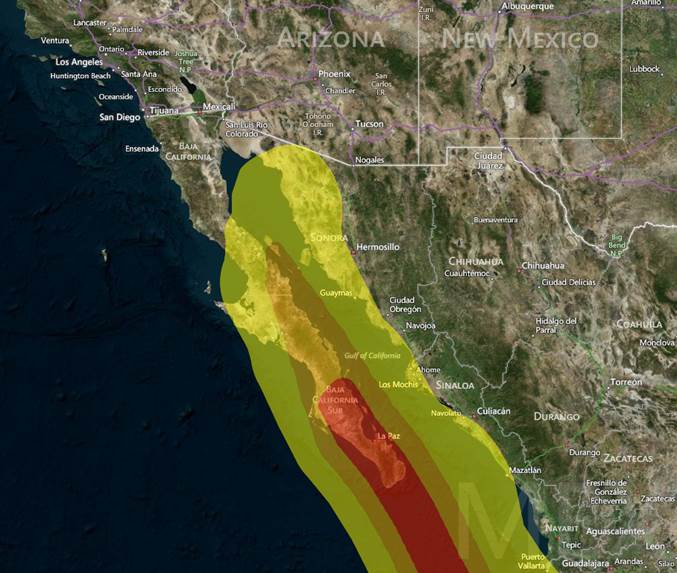
Figure 2. NOAA/NHC Cumulative Wind Swath for Hurricane Odile
The municipality of Los Cabos, including Cabos San Lucas and San Jose Del Cabo, and La Paz, the capitol city of Baja California Sur, sustained serious damage (Maps shown in Figure 3). The resort town of Cabo San Lucas, receiving the brunt of the storm, was hit hardest. Many of the upscale resort hotels and storefronts in the town were heavily damaged by the wind and rain. Several local airports were damaged, including the Los Cabos International and the La Paz Airports. With the airports incapable of commercial flight activity, thousands of stranded tourists had to be flown out of the storm-hit area by government planes. Many of the region’s homes were damaged or destroyed as well. The mayor of La Paz estimated that 10,000 houses in the town were damaged. Roads were flooded and blocked and some bridges collapsed. There are no official estimates of overall damage costs as of yet. In the face no electrical or water, some residents turned to looting local stores for supplies. After landfall the continually weakening, but still strong storm traveled up the Baja peninsula and into northwestern Mexico and the southwestern U.S.
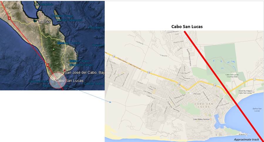
Figure 3. Impacted cities in Baja Peninsula
Contact us about our Global Cat Response services.

